If you live near the East Coast, hurricanes are a fact of life during the summer and early fall for most. In this episode of Weather Whys, host Ed Oswald looks at the Atlantic hurricane season in detail. Where hurricanes are most likely to form shifts throughout the season, leading up to a dramatic peak during September.
[00:00:22] If you’d like to watch a video of this podcast episode instead, we’ve included that in the show notes. We’ve also included graphics for you to follow along.
[00:00:30] I’m Ed Oswald, host of the Weather Whys podcast. I’m glad you could join us. Let’s get started.
[00:00:35] Ed Oswald: Hurricane season begins in the Atlantic on June 1st and ends on November 30th. Activity begins in the late spring and increases dramatically through mid September. After this peak, things quiet down in the fall.
[00:00:49] An Atlantic hurricane season typically has 10 named storms, six of which become hurricanes, and three of those major hurricanes. That’s a storm that reaches category three or higher on the Safir Simpson scale.
[00:01:00] However, activity isn’t always confined to hurricane season. For example, every four seasons or so the first name storm occurs in may, and about once a decade, a storm develops as late as December, but most hurricane activity occurs between June and November.
[00:01:16] Now let’s take a look at what to expect month by month.
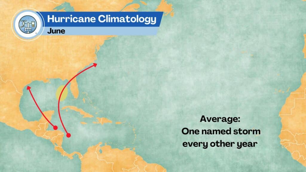
[00:01:19] We don’t look far from the coast for tropical development in June. Development is most likely in the Eastern Gulf of Mexico, especially if the waters are warm. These storms often start organizing in the warm waters of the Western Caribbean before pushing northward. Activity is light, with typically a single name storm during June.
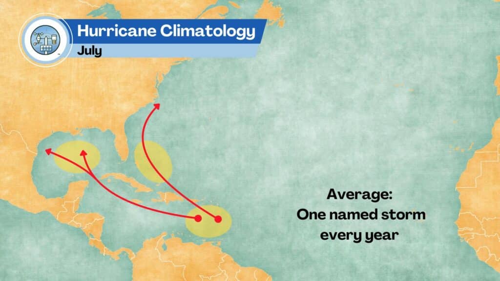
[00:01:37] The effects of the summer sun on water temperatures are apparent in July, as more of the tropical Atlantic Springs to life. While the Gulf of Mexico remains favorable, storms also have commonly formed in The Bahamas and the Eastern Caribbean.
[00:01:52] Storm tracks become longer as more of the Atlantic warms above 80 degrees Fahrenheit, allowing these storms to turn over the open sea and intensify. The Western and central portions of the Gulf coast see an increase in activity, and the Southeastern us is now under threat.
[00:02:07] While much more of the Atlantic can support tropical development, July still remains quiet. Expect an additional named storm during this month, but things are about to change dramatically.
[00:02:16] Waters are warm enough over a large section of the tropics by August to support development almost anywhere. Storms form further and further away from land, giving them more time to gain strength.
[00:02:26] Long track storms start to develop. Areas like the mid Atlantic coast and especially the outer banks come under threat.
[00:02:33] An average August has two to three named storms.
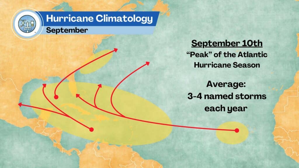
[00:02:35] September is even busier. Offshore waters off the Mid-Atlantic are now warm enough to support tropical development, the Cape Verde islands off the west African coast become the area to watch, and there aren’t many areas we’re tropical development can’t occur.
[00:02:49] Typical tracks come in three groups: storms in the Caribbean often head for the Western and central Gulf coast while Gulf storms typically move northward into Florida and up the east coast.
[00:03:00] Long track storms typically turn out to sea well before land, but must be watched, especially if you live on the Southeast or mid Atlantic coast or on Bermuda.
[00:03:08] The peak of the hurricane season is September 10th, and it’s not uncommon to see all of the three or four named storms that formed during the month, all churning through the Atlantic at that time.
[00:03:18] For most the transition into fall takes the attention off the tropics, but as we’ve seen in the past, Sandy, being the most well-known example, the season’s not over yet.
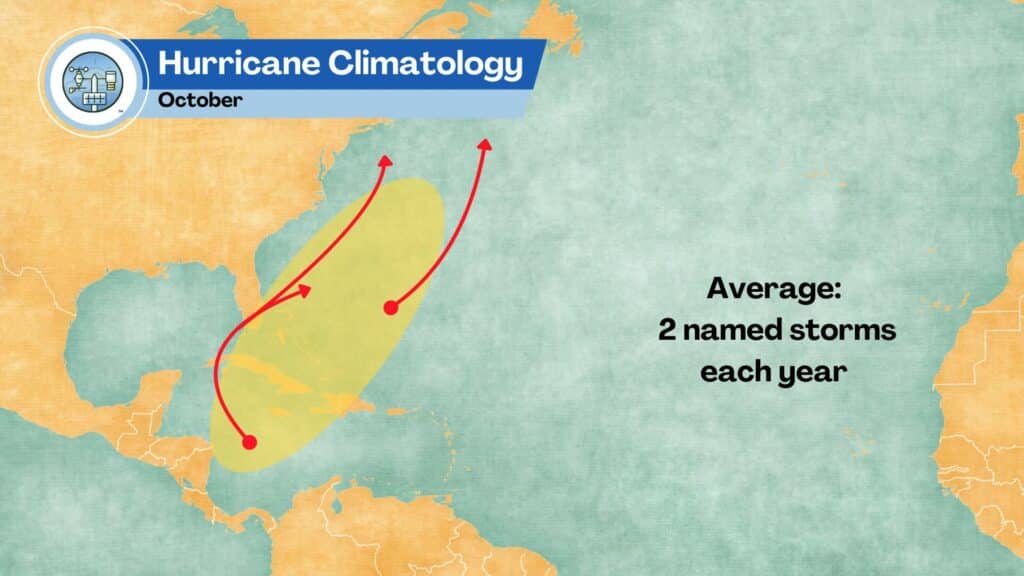
[00:03:27] While water temperatures are still warm in many places in October, wind shear returns, which is detrimental to tropical development. As a result, most development occurs closer to the coast, often due to old frontal boundaries.
[00:03:40] Storms in the Western Caribbean and the Gulf of Mexico should be watched as they may turn up the coast, becoming strong nor’easters. about two named storms will form during an average October.
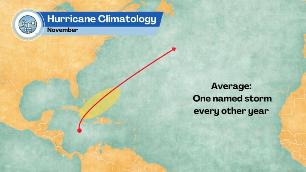
[00:03:50] Finally, in November things quite down with development limited to the central Caribbean. Most of these storms will push north and eastward. An average November has a storm about once every other season.
[00:04:01] But no matter where you live on the east coast, there is an increased chance for tropical development at some point during the summer or fall. The best thing to do is to keep a watchful eye on the tropics all season long.
[00:04:11] That’s all the time we have for this episode.
[00:04:14] Weather Whys is a production of the Weather Station Experts and the Weather Whys Company. Today’s episode was produced by Derek Oswald and myself from our studios here in West Lawn, Pennsylvania. if you’d like to learn more about Weather Whys, please visit our website at Weather Whys. show. That’s W H Y S. On our website, you can listen to this episode and any past episodes and also get in touch with us. We’d love to hear from you. Don’t forget to subscribe to Weather Whys to get the latest episodes as soon as we release them. You can find those links to Apple Podcasts, Spotify, Google, and more on our website as well.
[00:04:46] Thanks for tuning in, and as always, stay weatherwise.
Show Notes
Hurricane Season in the Atlantic Ocean runs from June 1 to November 30 each year. Activity isn’t always confined to this time period, though!
The average Atlantic hurricane season:
- 10 named storms
- 6 hurricanes
- 3 major hurricanes
That’s actually an increase from the past. See: The Average Hurricane Season is More Active Than Ever – The Weather Station Experts
The graphics below will make the discussion on where tropical development is most likely easier to follow.
In June and July, tropical formation occurs closer to the coast, and generally in the warm waters of the Carribbean.
In August, as the water temperatures warm, more of the Atlantic springs to life.

The peak of the hurricane season is September 10th.
Don’t forget about October and November!
Superstorm Sandy: A look back at the devastating storm 11 years later, 6abc Philadelphia – October 29, 2023
